Advertisement

News
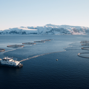
New FAO website shows location of aquaculture operations
FAO National Aquaculture Sector Overview (NASO) map collection uses “Google Maps and Google Earth” technology to assist FAO member countries to inventory and monitor aquaculture
A new website showing the locations of aquaculture sites and their characteristics is now available. The online National Aquaculture Sector Overview (NASO) map collection uses “Google Maps and Google Earth” technology to assist FAO member countries to inventory and monitor aquaculture. The collection is in its early stages but holds potential use in a number of ways such as monitoring the status and trends of aquaculture development and addressing site selection and zoning issues. The NASO map collection is coordinated by the Aquaculture Service of the FAO Fisheries and Aquaculture Department in close collaboration with FAO’s Fisheries and Aquaculture Statistics and Information Service. Visit the website.


Job Oportunities
-
Regional Business Development Director – APAC & ChinaMay 26, 2025
-
Food Safety & Quality Assurance Manager - USMay 21, 2025
-
Postdoctoral position – BrazilApril 23, 2025